User talk:Varghedin
Jump to navigation
Jump to search
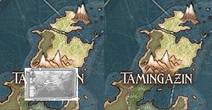
Tamingazin placement
Hi! I was looking at some of your maps and Otaria got me wondering with your placement of Tamingazin. I've always assumed they integrated it into Otaria in a different way (I may have kept the book map a bit too large and I do not account for other possible distortions, but that's roughly how I see it):

You can actually see some corresponding islands and in the map from the book, the Valley is supposed to be surrounded by higher, mountainous terrain. Would there be any issues with my placement? How did you choose yours? Ontos (talk) 00:58, 12 October 2025 (UTC)
- Thanks for this! Yes, I struggled trying to place it. First I thought it was only the uppermost part (the two-mountain island), but then I realized it had to be further south based on the terrain (woods in the west, plains in the middle). Also the name placement didn't match. But it also couldn't bee too far south as you quickly end up inside Krosa. I can look at it again. --Varghedin (talk) 08:15, 25 October 2025 (UTC)

- I decided to take a closer look again. First though - about those issues with being too close to Krosa - Ethan Fleischer, who made the most recent maps initially had similar issues (the map for The Prodigal Sorcerer being based on a part of the continent which was later used by another Creative Team to develop Otaria as if it was a blank page). He basically resolved it by having Suderbod collapse after their invasion into the Valley and the Cabal taking over the area in their wake. While Krosa forest would expand northward over the years.
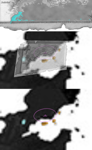
- So here's another map to confirm where Tamingazin is (still crude, but a little bit better attempt). First, at the top, I've painted over some of the book map's shallow waters - we can glean from it that there is indeed a land nearby in the South direction, consistent with a bay. And it's consistent that there may be an inlet of water going deeper into the land, in the lower left corner of the book map.
- I don't know what kind of distortions the map suffered in the process of photographing the original globe model, projection of those maps and whatever further digital edits Ethan made to it, but I tried my best to fit the outlines. It's also possible that when Pete Venters originally prepared the map for TPS, he made it in the North direction, but from some angle and that's why the southern edges of the bay interfered with an otherwise better, less messy fit. Either way, you can see now, where the four islands should be (with Tamin and Norumber - the latter got covered by the 'Tamingazin' name on Ethan's painted map) and where the Institute is.
- Your map is also missing a quite significant body of water. This lake also seems to be missing from TPS map (either Pete Venters didn't bother with it, or maybe because of the angle at which he photographed the globe, it ended up outside of it and Ethan's projection additionally caused this mismatch). But it's clearly there in black and white. You can also see it on the painted map, barely. I also would have missed it, had I not looked at the earlier rendering (which is also not covered by all the names). Ontos (talk) 16:36, 25 October 2025 (UTC)